
Surveying & Mapping VTOL Solution
Product-Level Solution, Rapid Innovation for Diverse Frames.
Multi-Rotor Mapping UAV Product Solution
Based on the the expertise in core components, SIYI offers a high-performance multi-rotor mapping UAV solution,
which can be quickly adapted to a variety of different frames.
Covering link & controllers, gimbal cameras, autopilots, propulsion systems and software, support Ardupilot/PX4.
Ready to use out of the box! Helping you rapidly accelerate your innovation speed!

UniRC 10 Pro
Triple-Frequency Professional Ground Station
 Triple Frequency 45KM Transmission (Ground-to-Air)
- 10.1 inch + 2000nit + 27CH
- IP54 industrial protection.
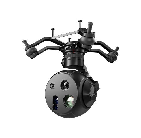
UniPod MT11
New-Era Multi-Sensor Optical AI Pod
- 8K + 48MP + 165x Zoom
- HD IR Vision + LRF function
- Built-in 10T AI, Human/ License/Fire Tracking
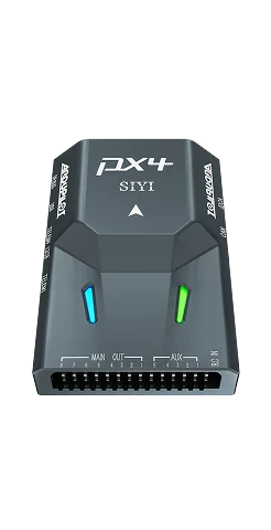
N7 + RTK Positioning & Orientation + MS4525 Airspeed
High-Precision Flight and Operation Control
- Dual-antenna heading
- cm-level RTK accuracy
- Digital stall prevention

UniGCS
Software
- Smart mapping routes
- Real-time telemetry & gimbal control
- Dual-mode RTK

Empowering Intelligent Surveying Operation
Provide highly integrated product-level solutions, allowing selection of appropriate product components based on actual project requirements. Powered by advanced HD video transmission, gimbal control, camera imaging, and control systems – Empower more professional emergency rescue operations.
Benfits
Link & Controller, Gimbal Cameras, Autopilots, Propulsion Systems, Software. All core components, fast integration!Empower global industriesk quickly integration & innovation, tailored to meet project requirements.
System-Level Deep Integration
Compared to traditional piecemeal assembly, SIYI provides a unified architecture with underlying protocols fully bridged. Power, flight control, link, and payload coordinate seamlessly, significantlyenhancing system stability, simplifying wiring, and enabling rapid installation.
Ultra-Low Total Cost of Ownership (TCO)
Through in-house R&D across the entire industrial chain and large-scale production, hardware procurement costs are significantly reduced. The modular maintenance design drastically lowers the total lifecycle operational cost.
Precise and Efficient
Using RTK dual-antenna heading determination technology, it completely eliminates reliance on a magnetic compass. Even when operating right next to a 500KV power line, it maintains centimeter-level stable hovering, enabling fine-detailed inspection of insulators.